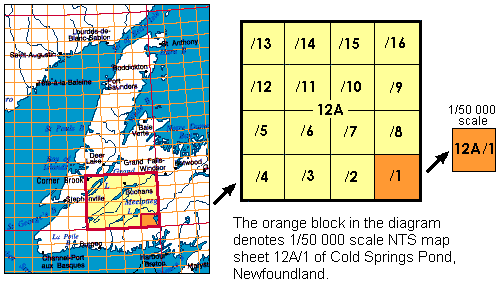
Topographic maps produced by Natural Resources Canada conform to the National Topographic System (NTS) of Canada. They are available in two standard scales, 1/50,000 and 1/250,000. The area covered by a given map sheet is determined by its latitude and longitude. Since the National Topographic System uses a standard numbering system, knowing the map number allows you to quickly identify adjacent map sheets. The 1/250 000 scale maps (1 cm equals 2.5 km) are identified by a combination of numbers and letters, from A through P (e.g. 12A, below in yellow). The 1/250 000 blocks are further sub-divided into sixteen segments (1 to 16), forming blocks used for 1/50 000 scale mapping (1 cm equals 0.5 km).